International Case studies
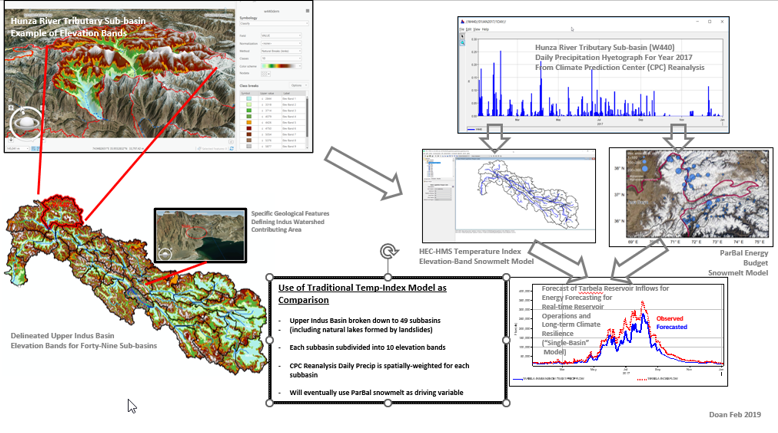
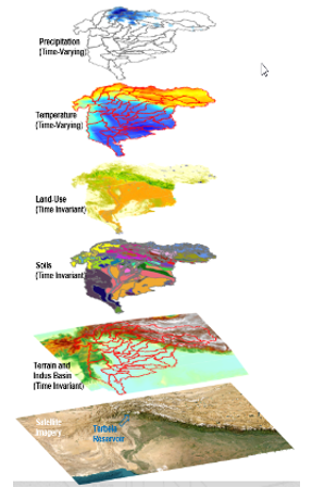
Indus River Basin in South Asia Hydrologic and Water Management Models
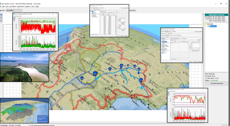
Parana River Basin Hydrologic and Water Management Models
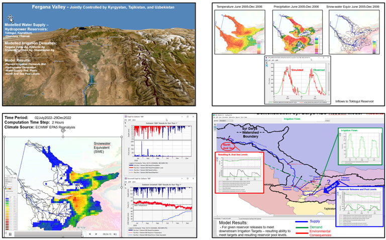
Syr Darya Aral Sea Basin in Central Asia Hydrologic and Water Management Models
Central America Hydrologic and Water Management Models

WATER SCARCITY AND CENTRAL ASIA’S GROWING IMPORTANCE FOR STABILITY IN AFGHANISTAN AND PAKISTAN. A MAJORITY STAFF REPORT
PREPARED FOR THE USE OF THE COMMITTEE ON FOREIGN RELATIONS. UNITED STATES SENATE. One Hundred Twelfth Congress First Session. February
22, 2011:
“The United States should support efforts in Central and South Asia to model changes to water flow and volume for entire river basins across a range of scenarios, from the
impacts of climate change to the construction of dams. Understanding these impacts, which generally take the form of reduced or irregular water flow, will help
governments make more informed decisions on water management. Today, most of these basins only have studies on the outcomes of individual projects, rather than the
cumulative impact of multiple projects. Without complete river basin analysis for the Amu Darya, Syr Darya, and Indus, countries in Central and South Asia are left to
negotiate water allocations and usage based on either the status quo or their own assumptions, neither of which lends itself to finding synergies. The United States should
support the development of basin-level water modeling and scenario analysis through technical exchanges and partnerships with Central Asian and Indian universities.
Basin-wide modeling is also useful for addressing tensions over hydroelectric dam proposals that continue to agitate countries sharing rivers. Dams are often the easiest
target for public scrutiny, blame, and anger when water flow changes, regardless of whether they are the culprit. For the major dam proposals in the region, such as Rogun
and Kishenganga, there is still no independent analysis of the cumulative impact these projects will have on water flow, especially during the low flow season. Providing
water flow models for a range of construction scenarios to all interested countries can form the basis for discussions on the utility of these projects.”
Global Water Security – INTELLIGENCE COMMUNITY ASSESSMENT. CA 2012-08, 2 February 2012:
”Hydrological Modeling for New and Revised Water-Sharing Agreements We judge that as global water demands increase, many nations included within the 263 shared
international water basins worldwide would benefit from new or updated international agreements. Effective water agreements encourage greater cooperation and lessen
the risk of regional conflicts. Today, water basin agreements often do not exist or are inadequate. Additionally, the absence of good hydrological modeling and water
flow/level measurements (from on the ground or via remote sensors) creates distrust among nations sharing a common basin. Shortcomings in water basin agreements
often further enable stronger states to preserve their influence over weaker states. Water-sharing agreements are often complicated by changes to the larger political
structure. After the collapse of the Soviet Union, management and sharing of the Amu Darya and Syr Darya Rivers became contentious. Barter arrangements, which
involved trading cheap fuel and electricity provided by downstream countries for water released by upstream countries, were interrupted. Implications for the United States
Many states turn to the developed world to find alternative ways to meet their infrastructure needs. Water planners in developing countries regularly lack adequate data
(hydrological models and actual water levels) for effective policymaking. For example, knowledge of water balances in specific tributaries, replenishment rates for shared
aquifers, or water demands in particular communities may be either unavailable or inaccessible. The developing world will probably expect the United States, as a leader in
technology, to continue development of hydrological models and remote environmental monitoring, as well as to disseminate this data and facilitate the integration of other
terrestrial resource management data on a global scale.”